 Developing Storm Map. (ABC News)
(NEW YORK) -- Gulf Coast states already dealing with massive floods are bracing for even more extreme weather as the first tropical storm of the season could form as early as Tuesday night.
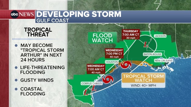
Tropical Storm watch issued for 2 states
The National Hurricane Center issued a tropical storm watch on Tuesday for the Gulf Coast from southeast Texas --including the cities of Brazosport, Galveston and Port Arthur-- to parts of southwestern Louisiana.
Potential Tropical Cyclone One, the name of the low-pressure system developing, is forecast to become a tropical storm later Tuesday or early Wednesday along the Gulf Coast.
If it becomes a tropical storm, it will be named Arthur, the first named storm of the 2026 Atlantic hurricane season.
A hurricane is not expected to form, according to the latest forecast.
Very heavy rain is forecast for New Orleans as early as Wednesday evening or as late as Thursday morning, depending on how quickly the storm develops. New Orleans is under a flood watch.
Winds will gust over 40 mph at times along the coast and coastal flooding may also become an issue, according to the forecast.
Deadly flash flood threat continues in the South
A woman in Bandera County, northwest of San Antonio, Texas, called 911 on Monday morning, saying her car was being swept away into a creek by floodwaters, the county's sheriff's office said on social media.
Within moments, the call dropped, the office said, and hours later the woman was found dead in the vehicle "several miles downstream" of its initial entry point, the sheriff's office said. The woman was not immediately identified.
In San Antonio, Houston and Waco there were stalled vehicles due to high waters on roads. In Shreveport, Louisiana, there were water rescues and water entering buildings.
In St. Martin, Mississippi, ramps to I-10 and I-110 were closed due to high waters. South of there, at Kessler Air Force Base, several roads became impassible.
More than 17 million Americans remain on Tuesday under a flood watch from Texas to Mississippi.
Heavy rainfall may lead to localized significant flash flooding from Corpus Christi to Houston to Lafayette and Alexandria, Louisiana, and McComb, Mississippi. A level 3 of 4 threat for flash flooding is in place there.
The greatest risk is likely along a frontal boundary laid over central Louisiana and into southeast Mississippi -- rainfall may be heavy for a few hours in this area on Tuesday and could lead to significant flooding.
Rains closer to the coast are going to be more difficult to sustain but there is certainly enough ingredients there that if they get going, localized instances of significant flash flooding are possible.
Tomorrow, the level 3 of 4 flood threat is for Houston, Beaumont, Lake Charles, and Lafayette.
On Thursday, the level 3 of 4 flood threat moves to Baton Rouge through Jackson, MS, Montgomery, AL and Birmingham, AL.
This heavier rain for Wednesday and Thursday will come from a developing tropical low over the western Gulf.
The National Hurricane Center gives it a 60% chance of forming into a tropical storm later on Tuesday or on Wednesday. If it becomes a tropical storm, it will be named Arthur, the first of the season.
Severe weather outbreak in the Midwest on Wednesday
About 40 million Americans are in the storm zone where a severe weather outbreak is expected on Wednesday
The greatest likelihood for a destructive outbreak is in Illinois and Indiana, and possible for parts of Missouri, Iowa and Ohio, too.
A level 4 of 5 moderate risk for destructive storms is in place for central Illinois and northern Indiana on Wednesday. This includes Springfield, Peoria, Decatur, Champaign and Bloomington, Illinois, along with Rensselaer, Indiana.
Large and long-lived tornadoes are possible, along with destructive wind gusts up to 80 mph, and hail up to the size of baseballs.
The level 3 of 4 risk includes Chicago, Indianapolis, St. Louis and Fort Wayne.
-ABC News' Ivan Pereira contributed to this report.
Copyright © 2026, ABC Audio. All rights reserved.
